How To Download & Use Your SolidPoint Boundary Survey
How to download, open and understand your SolidPoint boundary survey. Written for clients, solicitors and project teams.
Questions about your files? Call 01332 898350 or email projects@solidpoint.co.uk
Written by: J. Neville - Lead Land Surveyor
Published 23rd September 2026
In This Guide
Download Your Files
Downloading Your Files From Sync
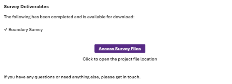
When your boundary survey is ready, you will receive an email from SolidPoint. Click Access Survey Files to open your project folder on Sync - our secure file-sharing site.
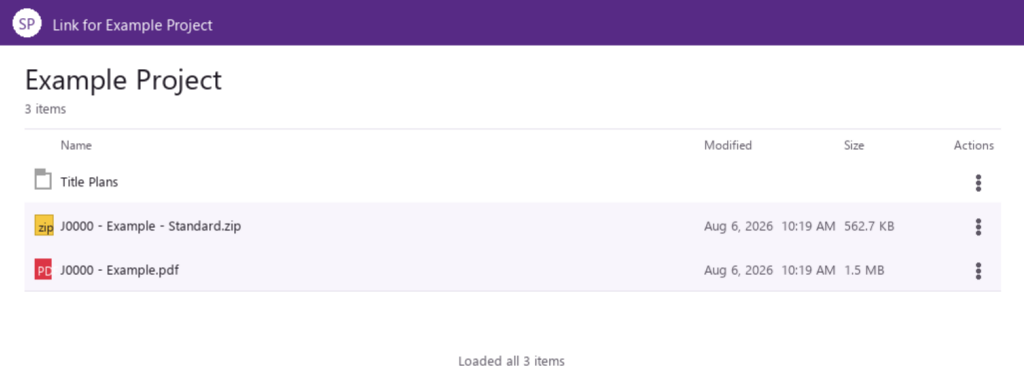
Use the three-dot menu on the right of each item to download. Download the PDF first if you only need to view the survey sheets.
Your Handover Email
Your Sync Project Folder
What Each File Is For
File Types
A standard boundary survey handover contains three items. Advisory reports are optional extras and are only included if commissioned separately.
PDF Survey Sheets
J0000 - Example.pdf
-
- The finished survey drawing(s) ready to view and share.
- Open with any PDF reader - no CAD software needed.
- Best starting point for most clients.
CAD eTransmit (ZIP)
J0000 - Example - Standard.zip
-
- Contains the 2D DWG CAD file(s).
- Packaged as an eTransmit so linked title-plan PDFs stay attached.
- Unzip the folder before opening the DWG.
Title Plans Folder
Title Plans
-
- Copies of the Land Registry title plan(s) used for comparison.
- Useful reference for you, your solicitor or your architect.
Optional Deliverable
Written advisory reports / further interpretation can be added for an additional fee.
Ask the project team if you need this.
Software To View Your Survey
You do not need specialist survey software to use your handover. Choose the option that matches the file you want to open.
If you only need to understand the survey, start with the PDF. Pass the DWG to your architect or CAD user if they need editable drawing data.
PDF Files (.pdf)
Recommended: Adobe Acrobat Reader (free)
Most browsers (Chrome, Edge, Safari) can also open PDFs directly. Use this for viewing sheets, sharing with others, and everyday reference.
Opens PDF survey sheets & Title plan PDFs
CAD Files (.dwg)
Recommended: Autodesk DWG TrueView (free)
TrueView lets you open, view, measure and plot DWG drawings. Unzip the eTransmit first, then open the DWG from inside the extracted folder so linked title plans remain available.
Opens 2D DWG boundary survey drawings from the ZIP
How To Read & Understand Your Drawing
Reading The Drawing
Your boundary drawing compares what was measured on site with Land Registry and Ordnance Survey information. Use the notes panel and annotations together.
If anything on your sheet is unclear, email the project team with the drawing number and we will talk you through it.
Left-Hand Notes Panel
Explains how the survey was related to the OS National Grid (OSGB36), which title plan was used, how the Land Registry outline was aligned, and important caveats about access and vegetation.
OS / Mapping Tolerance
Ordnance Survey maps are generally accurate but may contain errors within their stated positional tolerance (typically ±0.9 m). This is stated on the sheet - treat mapped lines as indicative, not exact legal edges.
Red Land Registry Outline
The red outline is traced from the Land Registry title plan (after alignment to the surveyed control / OS tile). It is for comparison with physical features on site.
Surveyed Features & Labels
Physical features such as wooden fences, concrete walls and posts (PO) are measured on site and labelled. Notes like “Fenceline surveyed from nearside” tell you which face was measured.
Dimensions
All dimensions on the survey are in metres. Offsets and comparisons help show how physical features relate to the title outline.
Title Block
Bottom / side title information includes job details, grid (OSGB36), level datum (e.g. ODN), control station (e.g. SP01), revision and survey type.
What The Survey Does & Does Not Confirm
What It Does Confirm
-
- Provides accurate measured information about physical features on site.
- Compares those features with available Land Registry title plans and OS mapping.
- Highlights indicative differences / relationships with dimensions.
- Gives you clearer evidence to discuss with neighbours, solicitors or designers.
What It Does Not Do
-
- It does not establish the exact legal boundary.
- It does not decide who owns a strip of land.
- It does not replace advice from a solicitor or suitably qualified boundary expert.
- Any “legal boundary” line shown is SolidPoint’s professional interpretation of the registered title relative to site evidence - it is indicative and subject to the tolerances noted on the sheet.
What To Do Next
Share The Right Files
If a solicitor or architect is involved, pass them the PDF and (if they use CAD) the unzipped DWG pack. The Title Plans folder is useful supporting context.
Talk Before Escalating
If the issue is with a neighbour and you are not yet instructing legal action, calm discussion or mediation may resolve matters without going further. The survey gives both sides clearer measured information.
One Included Amendment
We allow for one client amendment after issue. If something is missing because we did not meet the agreed scope, that is on us to correct. Further changes beyond that are charged at our hourly rate.
Printed Copies
Scale prints can be arranged and posted to you on request. There is an additional cost - we do not mark this up; it covers the print shop and delivery.
Email your surveyor to arrange.
Further Advice / Reports
Need a written interpretation or response to other information? Advisory reporting is available as an optional paid service. Ask the project team for details.
Need Help?
Stay updated with us:
How Can SolidPoint Help Your Project?
At SolidPoint, we are passionate about providing accurate and efficiently collected data for our clients and have worked on numerous projects across the UK. If you are looking to commission a survey in your next project, please don’t hesitate to Get in touch with a member of our friendly team to discuss your requirements and get a free quote.
Alternatively, you can call us on 01332 898350 or email us at projects@solidpoint.co.uk for more information on our services. We look forward to hearing from you!
Give us a call on
Request a Free Quote






Trusted Suppliers for: