How To Download & Use Your SolidPoint Topographical Survey
A practical, visual guide to your SolidPoint survey link, written for clients, architects, engineers and project teams
Questions about your files? Call 01332 898350 or email projects@solidpoint.co.uk
Written by: J. Neville - Senior Land Surveyor
Published 10th September 2026
Download this guide as a pdf
In This Guide
Accessing Your Files
Download Your Files From Sync
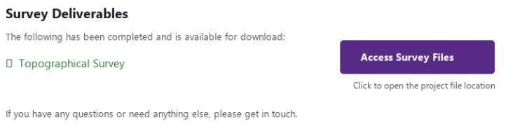
When your topographical survey is ready, you will receive an email from SolidPoint. Click Access Survey Files to open your project folder on Sync (our secure file-sharing site).
Click image to maximise
Step 1 - Your Handover Email
Click 'Access Survey Files'
Click image to maximise
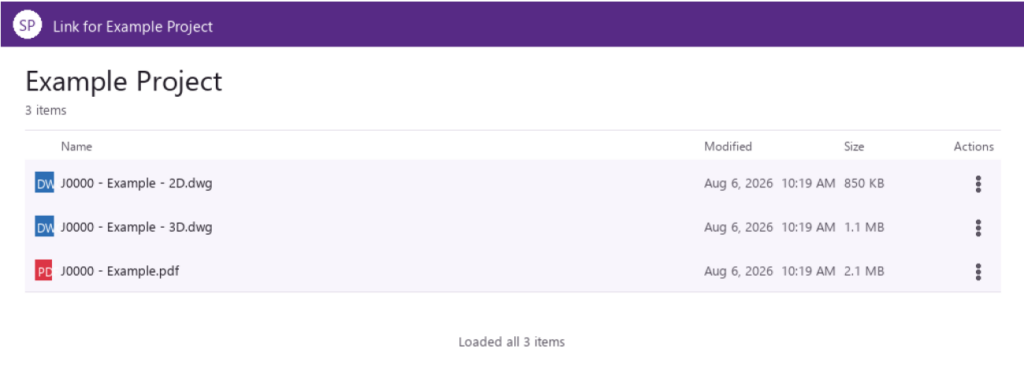
Step 2 - Your Sync Project Folder
This is an example of what your project folder could look like.
Use the three-dot menu on the right of each item to download.
Start with the PDF if you only need to view the survey sheets.
The CAD files open directly with no unzipping.
What Each File Is For
File Types
A standard topographical survey handover includes three files.
Exact filenames vary by job. Examples below use placeholder names only.
2D CAD File
J0000 - Example - 2D.dwg
The 2D plan drawing for architects, engineers and CAD users.
Open directly in DWG TrueView or AutoCAD, no unzipping required.
PDF Sheets
J0000 - Example.pdf
The finished survey drawing(s) ready to view and share.
Open with any PDF reader. This is the best starting point for most clients.
3D CAD File
J0000 - Example - 3D.dwg
Includes elevation / level data for design software.
Open directly, no unzipping required.
Optional - 3D TIN Surface
A 3D TIN surface can be provided upon request.
Ask the project team if your design workflow needs this.
Software to View Your Survey
Recommended Software
You do not need specialist survey software to use your handover. Download each file from Sync and open it directly, no unzipping required.
However, this is what we recommend. Both softwares are free to download.
Adobe Acrobat Reader
Use this for viewing your PDF survey sheets, sharing with others, and everyday reference.
Most browsers can open PDFs directly too.
Autodesk DWG TrueView
Allows you to open, view, measure and plot DWG drawings.
How to Read the Drawing
Your topographical drawing is a measured plan of the existing site features, surfaces and levels. The information panel sits on the right-hand side of the sheet:
Click images to maximise

Station Coordinates
Find on the right of the sheet.
Lists the survey control stations used on site, with their coordinates. These relate the survey to the Ordnance Survey National Grid (OSGB36) and the stated level datum.

Survey Legend
Shows what each symbol and line type means, including
-
- Buildings
- Boundaries
- Trees
- Drainage covers
- Surface changes
- Overhead services
- Other features recorded on site

Levels & Spot Heights
Numbers on the plan are ground levels (and often ridge, eaves or threshold levels where relevant).
All levels relate to the datum stated on the sheet (typically Ordnance Datum / ODN).

Surveyed Features
Physical features measured on site are shown in their surveyed positions.
This may include fences, walls, buildings, roads, kerbs, paths, trees, watercourses, street furniture and visible service covers.

Title Block
Includes
-
- Job details,
- Grid (OSGB36),
- Level datum,
- Revision and survey type.
Quote the drawing number if you contact us about the sheet.
Dimensions & Scale
All dimensions are in metres.
Use the scale bar / stated drawing scale when printing or measuring from the PDF.
For design work, prefer the DWG in CAD software.
What the Survey Does & Does Not Confirm
What Your Survey Does
-
- Provides an accurate measured record of visible site features and levels.
- Gives architects, engineers and designers reliable existing-site information to design from.
- Is normally related to the Ordnance Survey grid and a stated level datum.
- Helps reduce assumptions, redesigns and costly surprises later in the project.
What Your Survey Does Not Do
-
- It does not map underground utilities between covers, only visible surface evidence (covers, chambers, etc.).
- It does not replace a PAS 128 utility survey if you need buried services locating.
- Features hidden by dense vegetation, locked areas or obstructions may be incomplete and are normally noted on the drawing.
- Accuracy is appropriate for the agreed survey purpose - tell us how you will use the data so the specification matches your project.
What to Do Next
Share With Your Design Team
Pass the PDF to anyone who needs to view the site.
If an architect, engineer or CAD user is involved, also send the 2D and 3D CAD files.
Use It In Early Design
The survey is most valuable at the start of planning and design as proposals are based on real levels and features rather than assumptions or outdated mapping.
One Amendement Included
We allow for one client amendment after issue. If something is missing because we did not meet the agreed scope, that is on us to correct.
Further changes beyond that are charged at our hourly rate.
Printed Copies
Scale prints can be arranged and posted to you on request. There is an additional cost - we do not mark this up, it covers the print shop and delivery.
Email your surveyor or projects@solidpoint.co.uk to arrange.
Need More Information?
Underground services, boundary overlays or extra detail can often be added as a related survey.
Ask the project team what would best support your next stage.
Need Help?
Stay updated with us:
How Can SolidPoint Help Your Project?
At SolidPoint, we are passionate about providing accurate and efficiently collected data for our clients and have worked on numerous projects across the UK. If you are looking to commission a survey in your next project, please don’t hesitate to Get in touch with a member of our friendly team to discuss your requirements and get a free quote.
Alternatively, you can call us on 01332 898350 or email us at projects@solidpoint.co.uk for more information on our services. We look forward to hearing from you!
Give us a call on
Request a Free Quote






Trusted Suppliers for: