Churchill Business Park - Utility & CCTV Surveys
Client
Cube3 Construction
Industry
Industrial
Location
Doncaster
Written by J.Jackson | Published 21st September 2026

GPR / PAS 128 Utility Survey
Offers detailed, accurate mapping of underground utilities, crucial for efficient planning and preventing damages in construction and excavation projects.

CCTV Survey
This method of surveying underground drains and pipelines helps identify blockages, damage, and structural issues, ensuring efficient maintenance and preventing costly repairs.
Cube3 Construction commissioned SolidPoint to carry out a PAS 128 utility survey and CCTV drainage survey at Churchill Business Park in Doncaster.
The industrial site was being prepared for redevelopment, including refurbishment of an existing warehouse and proposals for a new structure on adjacent vacant land.
Client Goals
With excavation and new construction planned, the client needed a clearer understanding of the existing underground infrastructure before works progressed. Existing pipework and buried services were relatively unknown, creating potential risks during digging and construction.
The client had also experienced a costly service strike on a previous project, reinforcing the importance of locating buried utilities before excavation began. Alongside this, the existing drainage network needed to be assessed because the contractor was considering redirecting drainage and bringing existing sump pumps back into use.
The surveys therefore had two main objectives: identify and map buried services across the site, and establish the condition and usability of the accessible drainage network.

Our Approach
1. Utility Survey
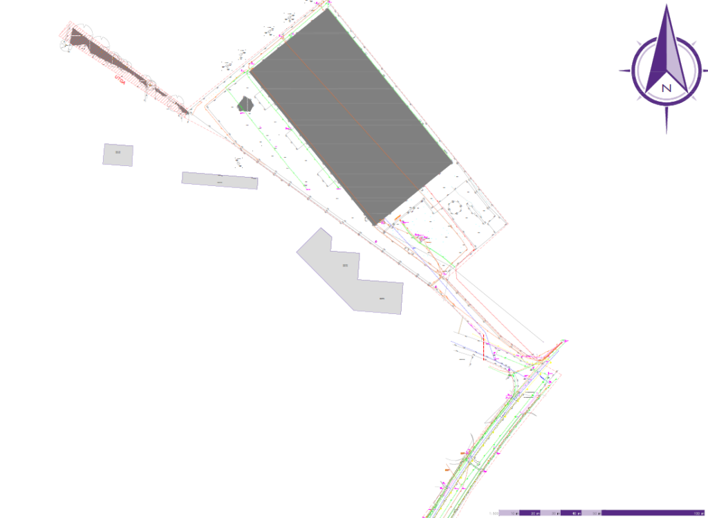
We carried out a PAS 128-compliant utility survey to investigate the buried services across the required areas of Churchill Business Park. PAS 128 utility surveys are designed to give project teams more reliable information about underground services before excavation, redevelopment and construction work begins.
The utility information was combined with our topographical survey data, allowing the underground services to be presented alongside relevant above-ground features, providing Cube3 Construction with clearer site context when reviewing proposed works, excavation areas and potential service routes.
2. CCTV Survey
A CCTV drainage survey was also completed to investigate accessible drainage runs of 75mm diameter or greater. This included combined sewers, foul drains and surface water drainage where access to the pipework was possible.
Specialist CCTV equipment was passed through the accessible drainage network to provide visual evidence of its internal condition. CCTV inspections can help identify issues such as cracking, blockages, collapses and other defects while also providing useful information about drainage connections and potential rerouting opportunities.
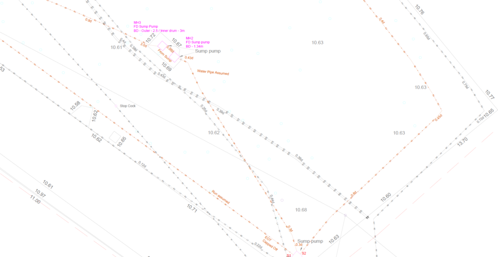
Drainage chambers were surveyed to a maximum depth of 3 metres from the manhole opening. Where drainage exceeded this depth, GPR could be used to attempt to trace the route, with further specialist techniques available where required.
Combining the CCTV drainage survey with PAS 128 utility mapping gave the client a more comprehensive understanding of what was beneath the site. The utility survey provided the wider underground service information, while the CCTV survey provided greater detail on the condition and connectivity of accessible drainage.
Project Deliverables
Following the surveys, Cube3 Construction received a detailed package of information to support the next stages of the project, including:
-
- AutoCAD/DWG survey drawings
- PDF survey drawings
- PAS 128 utility information and QA documentation
- Desktop utility survey information
- CCTV drainage report
- Drainage video footage and photographs
- Manhole cards and associated chamber information
- Written survey reporting


Utility Survey → CCTV Survey
How Did Our Client Benefit From a SolidPoint Land Survey Package?
Reduced risk during excavation
One of the most important benefits for Cube3 Construction was having more reliable information about the location of buried services before excavation began.
Utility strikes can result in repair costs, disruption, delays and additional health and safety risks. By carrying out a PAS 128 utility survey before groundworks, the project team could make decisions using surveyed information rather than relying solely on existing records or assumptions.
The resulting utility mapping gave the contractor greater confidence when planning excavation and construction work around the existing underground infrastructure.
Clearer understanding of drainage condition
Locating a drain does not necessarily tell a project team whether that drain is suitable for continued use.
The CCTV survey allowed accessible pipework to be visually inspected so Cube3 Construction could better understand the condition of the existing drainage system. This was particularly important because the redevelopment plans included the possibility of redirecting existing drainage and reactivating sump pumps.
Having both drainage mapping and CCTV footage gave the client evidence to help determine whether existing sections could potentially remain in use or whether repairs, replacement or alternative routing may need to be considered.
Better information for redevelopment planning
Combining the utility, CCTV drainage and topographical survey information created a more useful overall record of the site.
Rather than looking at underground utilities independently, Cube3 Construction could review them in relation to existing surface features and the proposed development area. This helped provide greater context when considering new structures, drainage alterations and future excavation.
The mapped drainage network also gives designers and contractors useful information when considering possible connections or rerouting options. SolidPoint's CCTV deliverables are designed to combine internal drainage inspection with mapped CAD information, helping project teams understand both the condition and location of the surveyed system.
Project Outcome
The completed surveys provided Cube3 Construction with a much clearer understanding of the underground conditions at Churchill Business Park before redevelopment progressed.
The PAS 128 utility survey reduced uncertainty surrounding buried services, while the CCTV drainage survey provided additional information about the accessible drainage network and its condition.
Together with the topographical survey, the information created a coordinated record that could support excavation planning, drainage alterations and the wider redevelopment of the site.
Why Choose SolidPoint?
For redevelopment projects involving excavation, new structures or changes to existing drainage, understanding what is already beneath the site can significantly reduce uncertainty.
By combining a PAS 128 utility survey and CCTV drainage survey, SolidPoint provided Cube3 Construction with information covering both the position of underground services and the condition of accessible drainage.
This gave the project team greater confidence when planning upcoming works, reduced the likelihood of unexpected buried services causing disruption, and provided useful evidence when deciding how existing drainage could be incorporated into the redevelopment.

Stay updated with us:
How Can SolidPoint Help Your Project?
At SolidPoint, we are passionate about providing accurate and efficiently collected data for our clients and have worked on numerous projects across the UK. If you are looking to commission a survey in your next project, please don’t hesitate to Get in touch with a member of our friendly team to discuss your requirements and get a free quote.
Alternatively, you can call us on 01332 898350 or email us at projects@solidpoint.co.uk for more information on our services. We look forward to hearing from you!
Give us a call on
Request a Free Quote


Trusted Suppliers for: