Everything You Need to Know About Buried Obstruction Surveys
Find everything you need to know about buried obstruction surveys, condensed into one short page
Written by: J.Jackson | Published: 25th September 2026
A buried obstruction survey helps project teams investigate what may be present below the surface before intrusive work begins. Using Ground Penetrating Radar, commonly known as GPR, surveyors can identify subsurface anomalies without digging up large areas of the site.
The results give designers, engineers and contractors more information about the ground they are working with, helping them plan foundations, excavations, drainage, utilities and other proposed works with fewer assumptions.
In This Page
Download this page as a pdf
What Is a Buried Obstruction Survey?

Buried Obstruction Surveys
A buried obstruction survey is a non-intrusive survey used to investigate objects, structures and unusual features beneath the ground.
Depending on the site and ground conditions, a buried obstruction survey may help locate:
-
- Old foundations and concrete slabs
- Buried walls and structural remains
- Underground tanks
- Basements, cellars and crypts
- Voids and areas of disturbed ground
-
- Abandoned pipes and drainage runs
- Reinforcement within concrete
- Large buried objects
- Archaeological features
- Previous construction beneath a site
The survey does not normally require excavation, making it a useful first step when the site history is unclear or when disturbing the surface would be costly, disruptive or unsafe.
Why Buried Obstruction Surveys Matter
Buried obstructions can affect almost every stage of a construction or redevelopment project.
Without suitable investigation, these issues may remain hidden until machinery begins breaking ground. At that stage, the project team may need to stop work, redesign part of the scheme or arrange additional excavation and removal.
A buried obstruction survey provides information earlier, while changes are usually easier and less expensive to make. It helps replace assumptions with measured site data and allows potential risks to be considered before the construction programme is committed.
The survey can also support safer planning. HSE guidance identifies planning, locating buried features and services, and safe excavation as key elements of reducing risks when working underground.
When Do You Need a Buried Obstruction Survey?
A buried obstruction survey may be useful whenever proposed works will extend below ground and there is uncertainty about the previous use or construction history of the site.
Common situations include:
-
- Before constructing new foundations
- Before piling or drilling
- Before excavation
- On previously developed land
-
- Where historic drawings are incomplete
- Before redevelopment or extensions
- Where a void or underground structure is suspected
- On heritage and archaeological sites
Key Benefits
Reduced Need for Exploratory Excavation
Traditional investigation may require trial pits or trenches to be excavated across several parts of a site.
A GPR survey can investigate a wider area without first breaking the surface. Targeted trial holes may still be required to confirm particular features, but the survey can help position them more effectively and reduce unnecessary excavation.
Non-Destructive Investigation
Because GPR operates from the surface, it can often be used without damaging paving, concrete, landscaped areas or sensitive ground.
This is particularly valuable on occupied sites, heritage locations, schools, public areas and completed developments where widespread excavation would cause disruption.
Useful Across Different Environments
Buried obstruction surveys can be carried out across a range of relatively level surfaces, including concrete, roads, car parks, fields, playgrounds and internal floors.
Their suitability and achievable depth will depend on the surface, ground conditions, access and the type of feature being investigated.
Improved Design Decisions
Survey results can be considered alongside the proposed design.
Engineers may use the information when reviewing foundation locations, drainage routes, utilities, service trenches or other below-ground elements. This allows decisions to be made using site-specific evidence instead of relying only on assumptions.
How Much Does a Buried Obstruction Survey Cost?
Our pricing calculator provides an instant guide to the cost of professional buried obstruction surveys across the UK. Simply draw the area that needs surveying on the map, select your survey types and get in touch!
How They Can Reduce Costs
The most significant savings usually come from identifying potential problems before work begins. When an obstruction is discovered during construction, the consequences can include idle labour, standing plant, additional excavation, waste removal, revised designs and delays to following trades.
Buried obstruction surveys may reduce costs by helping teams:
-
- Avoid unexpected stoppages during excavation
- Reduce emergency redesign work
- Position foundations away from major obstructions
- Plan the removal of buried structures in advance
- Reduce unnecessary trial excavation across large areas
- Select more suitable equipment and construction methods
- Produce more realistic programmes and budgets
- Coordinate below-ground works before contractors arrive on site
The survey cannot guarantee that every underground object will be found, but it can significantly improve the level of information available for planning and reduce the risk of proceeding with no knowledge of the subsurface conditions.
What Will You Receive?
Every project is different, so deliverables vary. Below, you can find what’s included as a standard in every SolidPoint buried obstruction survey.
No two scopes are the same, so neither are our processes – discuss your project’s needs with our surveyors, who will put together a package that works best for you.
You will receive:
Obstruction Drawings
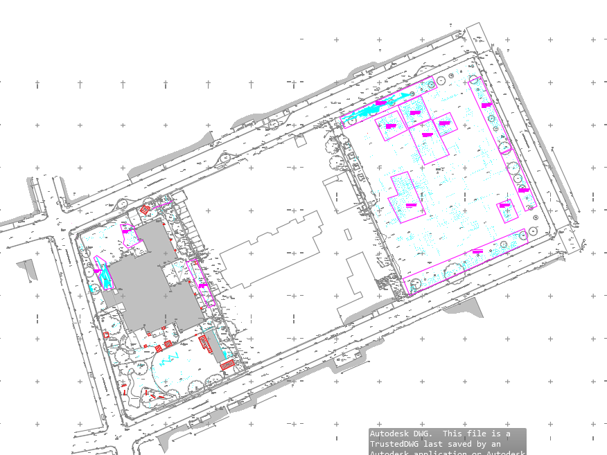
- DWG 2D Drawing with Depths and anomalies plotted and colour coded.
- PDF Sheets.
Survey Report
- A comprehensive PDF document summarising the survey findings.
Photographic Records
- Images taken during the survey to provide visual evidence of utility locations and conditions of site.
- Additionally, images of raw GPR Data as evidence.
- All images delivered as JPEG and/or PNG
*If you require a file format that isn't listed as our standard, please reach out to the team who will make reasonable adjustments to fit your scope.
PDF (Portable Document Format)
Standard for sharing reports and drawings - viewable on any device.
DWG (AutoCAD Drawing File)
Editable drawing files used for technical plans and mapping.
DXF (Drawing Exchange Format)
Compatible with various CAD programmes for design integration.
JPEG / PNG (Image Files)
Used for photographic documentation of site surveys and evidence.
Common Mistakes When Commissioning a Buried Obstruction Survey & How to Avoid Them
1. Confusing an Obstruction Survey with a Utility Survey
Buried obstruction surveys and utility surveys can both use GPR, but they do not always have the same objective.
A utility survey generally focuses on identifying service routes such as electricity, water, gas and telecommunications. A buried obstruction survey may focus more broadly on foundations, walls, tanks, voids and other structural or unidentified features.
How to avoid this:
Clearly explain what you are trying to find and why. Where both services and other obstructions are relevant, ask for a combined or appropriately coordinated survey rather than assuming one scope automatically covers the other.
2. Not Clearing the Survey Area
Parked vehicles, stored materials, dense vegetation, site cabins and other physical restrictions can prevent the GPR equipment from covering the full area.
Missing sections can leave uncertainty in some of the most important parts of the site.
How to avoid this:
Clear the survey area wherever reasonably possible before the visit. Identify fixed obstructions in advance so the surveyor can plan alternative access or explain which areas may not be covered.
3. Failing to Explain What Is Being Designed
A survey provider may be told to scan an area without being given any information about the proposed work.
Without this context, it is harder to determine the most useful survey grid, required depth, priority areas and suitable deliverables.
How to avoid this:
Provide foundation layouts, proposed drainage routes, excavation plans or other relevant design information where available. Explain whether the project involves piling, trenching, ground reduction, a new basement or another form of intrusive work.
Take a look at more common mistakes made, and other useful tips:
Conclusion
Buried obstruction surveys help project teams understand what may be hidden beneath a site before excavation, piling or construction begins.
By identifying possible foundations, tanks, voids, walls and other subsurface features early, the survey can reduce uncertainty and support safer, better-informed planning.
The greatest value comes from commissioning the survey early, setting a clear scope and understanding its limitations.
Stay updated with us:
How Can SolidPoint Help Your Project?
At SolidPoint, we are passionate about providing accurate and efficiently collected data for our clients and have worked on numerous projects across the UK. If you are looking to commission a survey in your next project, please don’t hesitate to Get in touch with a member of our friendly team to discuss your requirements and get a free quote.
Alternatively, you can call us on 01332 898350 or email us at projects@solidpoint.co.uk for more information on our services. We look forward to hearing from you!
Give us a call on
Request a Free Quote






Trusted Suppliers for: