
How to Commission a PAS128 Type B Utility Survey
What to send with a Type B request, and which detection method to ask us to name in the quote.
Written by: F. Wrzodak | Published 13th November 2026
This guide is here to help you commission a PAS 128:2022 Type B detection survey. If you would like a reminder of what a utility survey is, when it is useful, or how to read the files, you can find them here:
In this guide, we'll go through what you need to send us to request a Type B utility survey, a template to follow and some key points about what the survey involves to make sure you make the right decision.
Our team are always on hand to answer any questions and guide you through the process. If you need anything, just call or email.
Quick overview about records and surface checks:
A Type B survey is easier to interpret when the utility records are already in hand, and when those records have been compared with what can be seen on the ground.
Gathering the records is often called a Type D search.
Walking the site to relate them to covers, markers and reinstatement scars is a Type C check.
If you already hold current records, please send them while procuring your survey. If you don't have them, we can collect them for you, and we will carry out the surface check as part of the visit. The rest of this guide is about the detection survey itself.
What to Send Our Surveyors
1. Purpose
Whether you need the survey for design, pricing, excavation, a land sale, borehole clearance, or a model you will keep using, knowing this helps us put the effort where it matters.
2. A Marked Plan
A simple Google Maps screenshot with a marked out area showing the scope for the survey. Usually this is the boundary of the property and any area that would benefit from a closer search.
If you only need particular borehole or dig locations checked, let us know and we can price a clearance survey rather than a sweep of the whole site.
3. Records
Any records (with dates) you already hold are useful to us. We can also obtain these records for you, however it can take up to 15 days for us to receive a desktop search.
On private sites, the occupier’s own drawings are a great help.
4. Ground & Known Plant
Inform us of any Clay, made ground, a reinforced slab, the water table, and any materials, sizes or depths you already know about.
Wet clay and reinforcement make GPR harder to read, and a small plastic pipe is difficult to see when it's deep, so prior knowledge helps the survey run smoothly.
5. Access
We'll need to know about
-
- The hours our surveyors can be on site
- Any inductions
- Permits required
- Traffic management requirements
- Locked compounds
- Vehicles that can / cannot be moved
If any of these are not applicable to your project, just let us know.
6. Mark-Out
Let us know if you would like the services spray painted or chalked on the ground.
Paint fades, so the drawing is the reliable record. We need to know this because opting for paint or chalk requires a return visit, whereas going without doesn't. The return visit will be included in the fee, but our availability may change.
7. Background
Do you need a new topographical survey, do you already have one, and do you have a grid for control already in use are all questions our surveyors need to consider the answers to.
If you mention DXF or anything else beyond the usual set, we will do our best to fit it in.
8. Any Extras
If you require any of the following, please include this in your email too:
Entry into confined spaces. We measure chambers from the surface as standard. Going in is a separate instruction, with trained people and the right equipment.
CCTV condition surveys, quoted separately when you need to know the condition of a drain as well as its position.
Email Template to Get a Quote
You're welcome to use this template and send to projects@solidpoint.co.uk.
Fill in your own details where you see the purple text. Keep the lines that fit the project and leave the rest out.
Don't forget to attach your records
Subject Line - Quote request for a Type B Utility Survey at [address]
Good morning / afternoon,
I hope you're well.
I need a quote for a Type B Utility Survey. Details below:
Site and client - Name, address, and who we are contracting with.
Purpose - What decision the survey has to support.
Boundary - Plan attached. Closer-search areas hatched, with the reason. Full site, or clearance at marked positions only.
Records - Attached and in date / please obtain them. Private-network drawings attached if this is an occupied site.
Ground and known plant - Soils, slabs, materials, sizes, depths, if known.
Access - Hours, induction, permits, traffic management, compounds, vehicles. Chamber entry: not required / required and listed.
Mark-out - Drawing only / paint, including a return visit if GPR is post-processed.
Added scope - CCTV, or entry into confined spaces.
Please state in the proposal:
- Detection method for each area (M1, M1P, M2, M2P, M3P or M4P)
- Exclusions
- How unsurveyed areas will be shown
- Programme, including records
Kind regards,
Your name
Example
Good afternoon,
I hope you're well.
I need a quote for a Type B Utility Survey. Details below:
New substation and two boreholes, hospital site in Derby.
Please price a PAS 128:2022 Type B survey of the hatched area on the attached plan, about 1.2 hectares, including a records search if ours are out of date and a check of the covers and markers on site.
The two borehole positions marked in red would benefit from a closer search.
Estates drawings for the private network are attached.
We are not sure which detection method suits the site, so please suggest one for the general area and for the boreholes, and say whether the GPR will be post-processed.
Hours 08:00 to 17:00, induction required.
Please issue DWG and PDF on OSGB36, a report, a QA document, manhole cards and photographs. No paint mark-out.
Kind Regards,
Alan Sample
What the Survey Involves
1. The Standard Scope & Any Extras
Unless the proposal says otherwise, a SolidPoint Type B survey looks for the services below. CCTV and entry into confined spaces are available if you need them - just mention them in the request.
Included in the usual survey
-
- Metallic gas mains and metallic water mains of 38 mm diameter and above.
- Live electricity cables from 440 V to 66 kV, and street-lighting cables.
- Drainage of 100 mm and above, where the pipe can be accessed.
- Telephone, communications and data cables.
- Metallic fuel lines, empty ducts of 100 mm and above, underground heating pipes, and metallic pumping mains.
- Other metallic services that will carry a tracing signal.
- Depths where a reliable measurement can be made.
- Plastic pipes, tanks and voids are looked for with GPR, where the ground gives us a readable reflection.
Please ask if you need these
-
- Entry into confined spaces. We measure chambers from the surface as standard. Going in is a separate instruction, with trained people and the right equipment.
- CCTV condition surveys, quoted separately when you need the condition of a drain as well as its position.
2. Detection Methods
To recommend the detection method, we take into consideration:
-
- The purpose for the survey,
- The scope, and
- Any constraints you share with us.
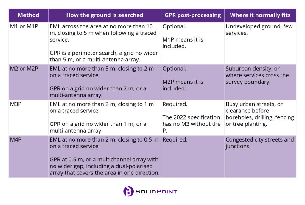
Below is a table explaining the different detection methods:
Click image to enlarge
The M code describes how closely the ground is swept.
A line that has been found can still carry any quality level from B1 to B4. A closer sweep simply gives us a better chance of finding what is there.
The figures in the table follow PAS 128:2022 Table 2, with the search lines held to about ±0.1 m.
The 'P' stands for post-processing. This means that we've interpreted the GPR back in the office, rather than only marking it on site.
PAS 128 asks for post-processing on every method above M2, and the proposal will say whether it is included.
A survey quoted as M1 is issued as picked on site. It is worth asking any quote to name the method for each area, whether the GPR will be post-processed, what sits outside the scope, and how we will show areas we could not reach.
If two quotes suggest different methods, we are happy to explain the difference before you decide. If the recommended search is more than the project can carry, we can look at a lighter one with you and note what that means for the result.
We use both EML and GPR, and record positions by GNSS or total station. On a busy M3P or M4P site, some lines will understandably sit below B1.
3. Quality Levels on Drawings
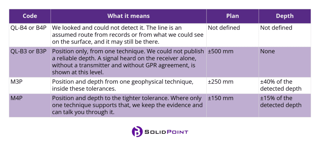
Please read each line on the drawings alongside the report.
Position is to the centre of the service, and depth is to the top, unless a note says invert.
At chambers, drainage is shown as a cover level and an invert.
Deeper than about 2m, the horizontal band of uncertainty widens a little.
A 'P' after the code means the GPR for that stretch was interpreted in the office.
Click image to enlarge
These are the Table 1 values in PAS 128:2022. Some services on a site will fall short of them, and that is a limit of the ground and the plant rather than a gap in the search.
Please keep B4 routes on the drawing. They show where we looked and could not confirm a service.
A careful survey will usually find somewhere around 80% to 95% of the utilities.
4. What You'll Receive
The quote lists what you will receive for the method we have agreed. An M1 survey is issued as picked on site. The usual package is:
-
- Utility drawings in DWG and PDF, colour-coded, with depths and the quality level on each line.
- Survey report, desktop records pack when we obtain it, manhole cards, site photographs, and the survey RAMS.
- A QA document, to give you assurance all checks have been executed.
Depths are in metres to the top of the services, unless a note says invert. A figure such as 0.25d means 0.25m below the top of the surface at that point. The drawing is best read with the report, and excavation is still carried out to HSG47.
Request a proposal
Tell us about your survey and we’ll help you take the next step.





Trusted Suppliers for:















Request a proposal
Use the full proposal form to add survey details and upload plans. Privacy policy