Liberty Place, Birmingham - Point Cloud Survey & 360 Images
Client
Creative CAD Ltd
Industry
Residential
Location
Birmingham
Written by J.Jackson | Published 4th September 2026

3D Laser Scanning
Point Cloud Surveys
Your Land and Buildings can be rapidly surveyed using 3D laser Scanners. This will provide an accurate existing or as-built 3D point cloud record of your land and buildings.

360° Tour
Provide a highly immersive and realistic experience of a space, which can be used for marketing or visualisation purposes, showcase properties, and more.
SolidPoint was commissioned by Creative CAD Ltd to complete a detailed Point Cloud Survey at Liberty Place, a residential development in Birmingham.
The project focused specifically on the balconies of five individual flats. Rather than requiring a full measured survey of each apartment, the client needed accurate existing measurements of the balcony areas that could be used for their subsequent design and modelling work, including:
-
- The complete balcony footprint,
- Surrounding walls and surfaces,
- Door thresholds,
- Internal floor levels, and
- The parapet walls beneath the existing railings.
Our client also required 360 images alongside the measured data, providing additional visual context when reviewing the balconies away from site.
Our Approach
The survey was carefully scoped around the areas that would be most important to Creative CAD Ltd when using the information later in their workflow.
Our surveyor captured both colour and black & white point cloud scans, paying particular attention to features where small dimensional differences could be important.
This included recording the door thresholds, including both their height and profile, as well as capturing the internal floor level immediately inside each doorway. Having these relative levels available within the survey data gave the client a much clearer understanding of how each apartment connected with its external balcony.

The parapet walls were another important part of the survey. Where railings were present above the walls, the scanner was positioned to capture clearly beneath them wherever access and visibility allowed. This helped provide a more complete representation of the surfaces rather than simply recording the most easily visible elements.
We also captured the full extent of each balcony. Loose and movable objects were repositioned where necessary so that areas hidden beneath or behind them could be surveyed rather than leaving unnecessary gaps in the dataset.
Alongside the measured information, fifteen 360 images were captured for each balcony, providing our client with a detailed visual reference to accompany the point cloud.
Project Deliverables
Following the site visit, the scan information was processed and registered by our team. The completed dataset was then indexed into RCP point cloud format, making it suitable for use within Autodesk applications and giving Creative CAD Ltd the flexibility to use the information within its own modelling workflow.
How Did Our Client Benefit From a SolidPoint Survey Package?
1. Accurate Balcony Measurements for Further Design Work
The main requirement for the project was accuracy.
By combining laser scanning and hand measurements, the client received a much broader digital record of each surveyed area.
This was particularly valuable around the thresholds and changes in level, where understanding the relationship between different surfaces was an important part of the brief.
2. Data That Could Be Used to Create 3D Models
Another key benefit was the flexibility of the final deliverable.
Measurements can be taken from the dataset during later stages of the project, including dimensions that may not necessarily have been identified as a priority before the survey took place.
For a CAD-based workflow, this provides a much more useful foundation than relying solely on written dimensions or individual site photographs.
It also reduces the risk of design work being developed from assumptions about the existing building.
3. A Detailed Visual Record Without Returning to Site
The point cloud was supported by 360 imagery.
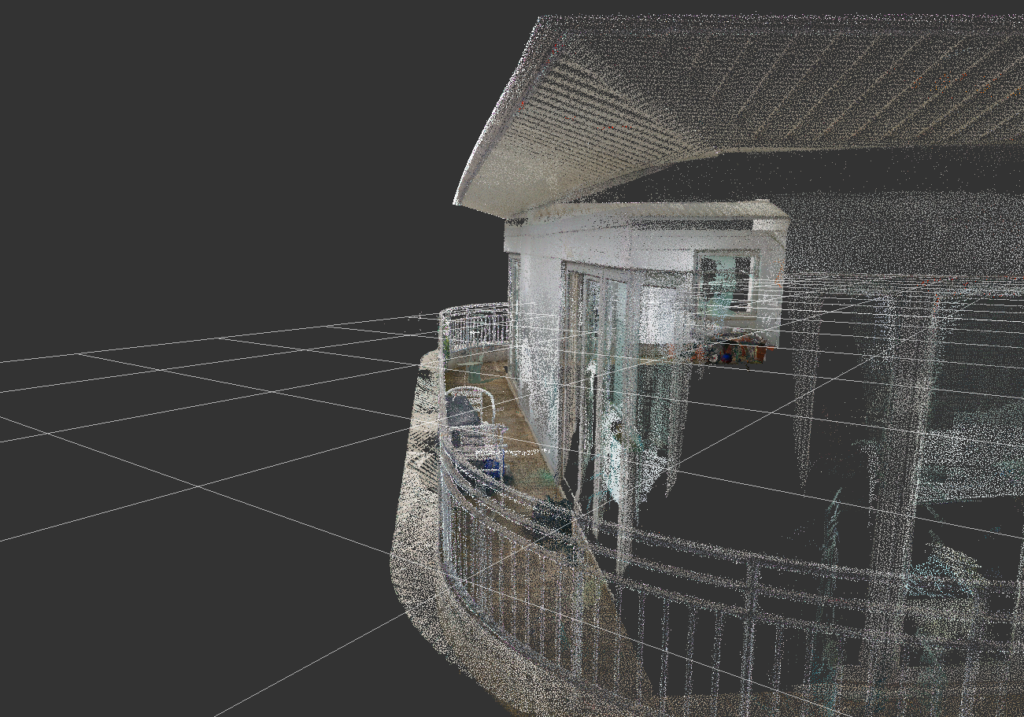
With 15 photographs captured for each balcony, the client received a comprehensive visual reference alongside the measured survey information, providing further context from the scanner positions and helped create a clearer understanding of the relationship between the different surveyed elements.
That gives the client both accurate dimensional information and a visual record of the surveyed areas in one coordinated package.
Project Outcome
The site survey itself was completed within 8 hours, followed by approximately 1 day of processing before the final point cloud information and accompanying imagery was delivered.

Why Choose SolidPoint?
This Point Cloud Survey in Birmingham demonstrates how laser scanning can be applied to a very specific survey requirement rather than only being used to capture entire buildings.
For a total project cost of £1,278, the client received a focused survey package designed around the information it actually needed, providing accurate measurements, flexible 3D data and a valuable visual reference for the next stage of the project.

Stay updated with us:
How Can SolidPoint Help Your Project?
At SolidPoint, we are passionate about providing accurate and efficiently collected data for our clients and have worked on numerous projects across the UK. If you are looking to commission a survey in your next project, please don’t hesitate to Get in touch with a member of our friendly team to discuss your requirements and get a free quote.
Alternatively, you can call us on 01332 898350 or email us at projects@solidpoint.co.uk for more information on our services. We look forward to hearing from you!
Give us a call on
Request a Free Quote


Trusted Suppliers for: